The responses below are provided to help clarify questions related to the Study of Potential Disadvantaged Community Designations. To navigate this page, scroll down to review each question and its response, or click on the desired question to jump to its response. Click on “Return to Top” in each question to return to the top of this page.
Click here to download the Frequently Asked Questions as a PDF.
Click here to return to the project website.
- What is a Designated Disadvantaged Community (DDC)?
- What areas is the County studying to potentially designate as disadvantaged communities and why?
- How was my area identified as low-income and/or affected by pollution? Where does the data come from?
- What is CalEnviroScreen? Where does CalEnviroScreen data come from?
- How does CalEnviroScreen calculate its scores?
- What is the County doing to reduce my community’s pollution burden and improve my community’s economic status?
- What are the drawbacks and advantages to being a DDC?
- Will my property value change if I live in a County DDC?
- What if I live in a city within the County of Ventura?
- Who should I contact if I have additional questions about my city?
- Why does my community have a high pesticide score in CalEnviroScreen?
- If CalEnviroScreen says that large amounts of pesticide are applied in my area, does that mean I am being exposed to dangerous toxins?
- How do I find out when pesticides will be applied near my home or my child’s school? How can I find out what pesticides have been applied?
- What does the County do to protect people who live around areas where pesticides are being used?
- Is my water safe to drink or use?
- Why does my community have a high CalEnviroScreen score for drinking water contaminants?
- How do impaired water bodies and groundwater threats affect my water quality?
- What is the County doing to protect my water?
- Why does my community have a high CalEnviroScreen score for hazardous waste?
- How does living near hazardous waste and hazardous materials affect my health or community?
General
1. What is a Designated Disadvantaged Community (DDC)? Return to Top
A Designated Disadvantaged Community (DDC) is defined in Senate Bill 1000 (2016) and the Ventura County General Plan (“General Plan”) as a low-income area that is disproportionately affected by environmental pollution and other hazards that can lead to negative health effects, exposure, or environmental degradation. Low-income communities are areas with median household incomes at or below 80 percent of the statewide median household income. The definition of a DDC is used to identify disadvantaged communities in this Study. Other government agencies may use different definitions for a disadvantaged community in order to meet their agency objectives.
The General Plan includes a program that requires the County to evaluate certain unincorporated areas throughout the county to determine whether they meet the definition of a disadvantaged community. Unincorporated areas near the cities of Oxnard, Ventura, and Santa Paula (referred to as “Study Areas”) were closely evaluated because information compiled by the California Environmental Protection Agency (CalEPA) and the United States Census Bureau indicate that disproportionate environmental pollution and socioeconomic burdens may exist in these areas. The County has already designated the unincorporated areas of El Rio/Del Norte, Saticoy, and Piru as disadvantaged communities when the County General Plan Update occurred in fall 2020.
To determine the low-income status of a Study Area, the median household income data is obtained from the United States Census Bureau and compared to the state median household income established by the California Department of Housing and Community Development.
To determine the environmental pollution burden in a Study Area, the state uses data compiled by CalEPA on various potential sources of environmental pollution. This data is entered into a state-run database called CalEnviroScreen.
Both environmental pollution data and income data are organized by census tracts, which are geographic areas established by the federal government. Census tracts with a percentile score at or above 75 in CalEnviroScreen are considered disproportionately burdened by environmental pollution. The County also reviewed data from other health and environmental screening tools, such as the Healthy Places Index. These sources are used in conjunction with CalEnviroScreen to determine the overall environmental pollution burden of a census tract within a Study Area.
CalEnviroScreen
4. What is CalEnviroScreen? Where does CalEnviroScreen data come from? Return to Top
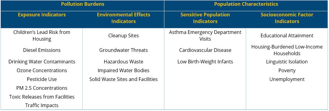
CalEnviroScreen is a computerized mapping tool created by the California Office of Environmental Health Hazard Assessment (OEHHA) within CalEPA that uses technical data to identify the extent to which communities are burdened with and vulnerable to pollution, compared to other communities throughout the state. It uses a total of 21 indicators from two major categories, “Pollution Burdens” and “Population Characteristics,” to calculate a score for each census tract in California. Calenviroscreen 4.0 Tool
CalEnviroScreen’s interactive map displays this overall score, as well as each individual indicator score. The data compiled in CalEnviroScreen comes from a variety of sources, including state and federal agencies, which are integrated into the tool as newer data becomes available. CalEnviroScreen 4.0, the latest version, is available online and can be accessed by scanning or clicking on the QR code shown.
5. How does CalEnviroScreen calculate its scores? Return to Top
CalEnviroScreen calculates an overall percentile score for each census tract based on two scoring categories: “Pollution Burdens” and “Population Characteristics.” Table 1 below shows the four categories of data (21 indicators) that are collected and included in CalEnviroScreen.
Table 1. CalEnviroScreen Indicators
Scores are calculated based on this data, as shown in Diagram 1 below. A higher overall score means that the census tract has the potential for greater overall pollution burdens and population vulnerability. Scores in the 75th percentile or higher meet the State and County criteria for disadvantaged community designation. (If a census tract has a score of 75, it means that it scored higher than 75 percent of all other census tracts in California.)
Diagram 1 - CalEnviroScreen Overall Score Equation
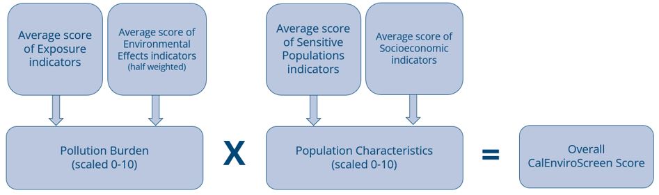
It is important to note, however, that a high CalEnviroScreen score does not confirm actual exposure to, or the presence of, environmental pollution or contaminants in a given census tract. CalEnviroScreen compiles data on pollution sources, pollution releases, and environmental concentrations as indicators of potential risk of human exposures to pollutants. Additionally, CalEnviroScreen does not measure the likelihood of experiencing health or environmental effects in a particular area.
Impacts of Being a DDC
The goal of this project is to study the potential designation of disadvantaged communities in the unincorporated areas near the cities of Ventura, Oxnard, and Santa Paula. Once designated, the areas would be covered by policies and programs outlined in the General Plan that specifically address DDCs.  Ventura County General Plan
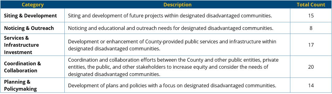
The General Plan includes 42 goals, policies, and programs that specifically focus on DDCs as summarized in Table 2 below. The General Plan is available online and can be accessed by scanning or clicking on the QR code shown for details of each goal, policy, and program.
Table 2. DDC Goals, Policies, and Programs in the General Plan
7. What are the drawbacks and advantages to being a DDC? Return to Top
As seen in Table 2 above, the General Plan includes policies and programs that increase governmental support and resources for County DDCs, as well as create the potential for greater scrutiny on future development and land uses that may result in further environmental pollution and socioeconomic burdens. For example, General Plan policies may require a permit applicant within a DDC to provide project notifications beyond the current notice requirements, which may result in additional costs for applicants proposing projects within DDCs. Some projects within DDCs may qualify for priority grant funding if the intention of those projects is to benefit or enhance the DDC, such as public infrastructure improvement projects or certain climate adaption and resiliency projects. Some examples of grant funding opportunities include the California Climate Investments Program and the Sustainable Communities Program. Some grant funding opportunities are available to local government agencies and tribal governments, while some opportunities directly fund businesses, farmers, nonprofits, and individuals.
8. Will my property value change if I live in a County DDC? Return to Top
The designation as a disadvantaged community is not listed on property records, and it is not incorporated into property deeds. No change in property value is anticipated as a result of disadvantaged community designation. Sellers are not required to disclose that their property is located within a County-designated DDC.
Decision-Making
9. What if I live in a city within the County of Ventura? Return to Top
The County is studying potential designations of disadvantaged communities in unincorporated areas of Ventura County, which are areas outside of incorporated cities. The County does not have regulatory authority to designate disadvantaged communities within cities. Each city is responsible for identifying disadvantaged communities within its own jurisdictional boundaries as required by the State of California (Senate Bill 1000[1]). This Study and any potential designation will not affect land within a city’s jurisdictional boundary.
10. Who should I contact if I have additional questions about my city? Return to Top
The County is coordinating with cities adjacent to the Study Area, which includes the cities of Ventura, Oxnard, and Santa Paula, to help keep these cities informed on disadvantaged community designations and boundaries. Please contact the appropriate city to find out more information on disadvantaged communities and policies within its respective jurisdiction.
Questions for the City of Ventura can be directed to the Community Development Department - Planning Division by phone at (805) 654-7869, or via email at This email address is being protected from spambots. You need JavaScript enabled to view it..
Questions for the City of Oxnard can be directed to the Community Development Department - Planning & Sustainability Division by phone at (805) 385-7858, or via email at This email address is being protected from spambots. You need JavaScript enabled to view it.. The City of Oxnard’s certified Housing Element contains the latest information on the city’s disadvantaged communities, which is available HERE.
Questions for the City of Santa Paula can be directed to the Community Development Department – Planning Division, at (805) 933-4214 or at This email address is being protected from spambots. You need JavaScript enabled to view it.. The City of Santa Paula’s Housing Element Update, which contains the latest information on the city’s disadvantaged communities in its Affirmatively Furthering Fair Housing appendices, is also available at www.mysantapaula.com.
Pesticide Use
11. Why does my community have a high pesticide score in CalEnviroScreen? Return to Top
CalEnviroScreen considers 132 pesticide active ingredients in its evaluation of the Pesticide Use  CalEnviroScreen 4.0 Reportindicator. These pesticides are listed in the appendix to the section on pesticides in the CalEnviroScreen 4.0 Report, which is available online and can be accessed by scanning or clicking on the QR code shown. Four of the 132 listed ingredients are fumigants that are often used by Ventura County growers of strawberries, caneberries, and peppers. These crops are especially prevalent in the Oxnard Plain. In CalEnviroscreen, fumigants contribute disproportionately to the Pesticide Use indicator score because they are applied at significantly higher application rates per acre than the non-fumigant pesticides CalEnviroScreen considers.
In California, all agricultural pesticide use must be reported to county agricultural commissioners, who then report this data to the California Department of Pesticide Regulation. CalEnviroScreen scores are based on the Department of Pesticide Regulation’s reported amount of applied agricultural pesticides. CalEnviroScreen scores are not a measure of pesticide contamination, or cases where pesticides may have moved or “drifted” into areas where they were not intentionally applied. CalEnviroScreen does not document or collect information on exposure incidents to pesticides, and thus cannot measure the likelihood of experiencing health or environmental effects in a particular area due to pesticide use.
While CalEnviroScreen records a large amount of applied fumigants, Ventura County’s Pesticide Use Enforcement Program enforces application practices that keep exposure to pesticides well below established safe exposure thresholds established by the United States Environmental Protection Agency (EPA). For example, when fumigants are applied near residences, they are covered in a multi-layer tarp (technically referred to as Totally Impermeable Film), which acts as a barrier and allows for the gradual fumigant release through the soil, such that any exposure to bystanders or workers in the field would be at levels well below EPA-established health concern thresholds.
The California Department of Pesticide Regulation (DPR) is developing a Pesticide Notification System  Proposed Regulations on Statewide Notification to notify participants when agricultural pesticides are to be applied. This program is proposed to be codified in the California Code of Regulations and has not yet been adopted. Information on the proposed regulations can be accessed by scanning or clicking on the QR code shown.
To find out what pesticides have been applied, pesticide use reports and summary spreadsheets are publicly  Pesticide Information Portal
  Statewide Pilot Programavailable by request through the Ventura County Department of Agriculture/Weights & Measures. Pesticide use information can also be accessed online through the California Pesticide Information Portal by scanning or clicking on the QR code shown, or by calling the Ventura County Pesticide Use Enforcement Program at 805-933-2926 (Santa Paula office) or at 805-388-4222 (Camarillo office). The California Code of Regulations section 6692 requires that growers provide annual notification to public K-12 schools and child day care centers located within one-quarter mile of all anticipated pesticide applications in the coming year. Parents can get this information from their school or daycare center.
The Ventura County Agricultural Commissioner enforces the proper use of pesticides through the Pesticide Use Enforcement Program, which issues permits for certain pesticides, conducts on-site CASPIR App Information inspections, collects pesticide data, and investigates potential violations of laws and regulations related to pesticide use. Investigations of pesticide misuse stem from state referrals through doctor visits, calls through the California Poison Control System, and local complaints. Inspections can be conducted without notice for pesticide applications and worksite conditions in fields treated with pesticide. Each investigation or inspection that documents one or more violation generates an enforcement response. That response may be a compliance action such as a violation or warning letter, or an enforcement action such as a fine or the revocation of a permit, registration, or license.
In 2022, the Ventura County Department of Agriculture / Weights & Measures conducted 798 inspections and investigated 50 pesticide-related complaints, which resulted in 88 enforcement actions (fines).
Members of the public are encouraged to immediately report suspected misuse of pesticides or incidents of potential exposure to pesticides or pesticide-related illnesses by calling 805-933-2926 (Santa Paula office) or at 805-388-4222 (Camarillo office). Pesticide incidents can also be reported through a new mobile app developed by the California Department of Pesticide Regulation called “California’s System for Pesticide Incident Reporting” (CASPIR). More information on the CASPIR mobile app can be accessed by scanning or clicking on the QR code shown.
Water Resources
15. Is my water safe to drink or use? Return to Top
The County of Ventura Water and Sanitation Department provides water and sewer services to about 13,600 customers throughout four water districts and seven sewer districts and service areas.  Water and Sanitation Dept. Reports There are over 150 other water purveyors in Ventura County, which include cities, water districts, mutual water companies, private water companies, and private wells. Water provided
through the Water and Sanitation Department is safe for human consumption. Water quality reports and water management plans for districts within the Water and Sanitation Department’s jurisdiction are available online and can be accessed by scanning or clicking on the QR code shown. For information on water quality provided through other water purveyors, please contact that water purveyor directly. Additionally, public water systems (serving 15+ connections) are regulated by the State Division of Drinking Water, which mandates testing and publishes an annual Consumer Confidence Report, which may be found online by scanning or clicking on the QR code shown. For information related to water safety within the cities of Ventura, Santa Paula, and Oxnard, please consult these cities directly.
The Drinking Water Contaminants indicator in CalEnviroScreen uses reported concentrations of contaminants and Consumer Confidence Report violations of drinking water standards, and whether certain contaminants were present from 2011-2019, which is the most current data available. It is important to note that the indicator scores do not reflect whether drinking water is safe. The scores represent average contaminant levels from all water sources within a geographic area. According to the California Division of Drinking Water’s 2018 Annual Compliance Report, 95 percent of public water systems, serving approximately 88 percent of Californians, delivered water that met all federal and state drinking water standards. However, drinking water quality varies with location, water source, treatment method, and the ability of the water purveyor to remove contaminants before distribution. Additionally, CalEnviroScreen scores may not be reflective of the water quality in a household as numerous systems may supply water to communities within one census tract. Drinking water quality information is typically included in the water purveyor’s Consumer Confidence Report, which may be found online by scanning or clicking on the QR code shown.
Threats to water quality include pollution or contamination that may come from sources such as wastewater treatment plants, failing systems, urban stormwater runoff, agricultural runoff, underground storage tanks, cleanup and land disposal sites, bacterial contamination, seawater intrusion, and naturally occurring contaminants. Impaired  Impaired Waters Reportwater bodies are considered compromised for drinking, swimming, fishing, aquatic life, and other beneficial uses due to pollution or contamination of that water, which violates water quality standards. The State Water Resources Control Board administers the listing and reporting of impaired water bodies in California. The most recent report of impaired water bodies can be accessed online by scanning or clicking on the QR code shown.
 CalEnviroscreen Indicator MapsOther threats to groundwater such as underground storage tanks and other facilities that handle hazardous materials or generate hazardous waste are regulated by the Ventura County Environmental Health Division, which conducts inspections of these facilities to help ensure their compliance with state and federal regulations. State and federal agencies such as the Department of Toxic Substances Control and the U.S. Environmental Protection Agency regulate and monitor cleanup at sites that have had significant release in the environment. Hazardous sites and facilities are mapped on CalEnviroScreen's indicator maps, which can be viewed online by scanning or clicking on the QR code shown.
18. What is the County doing to protect my water? Return to Top
Drinking water quality is regulated by the State Water Resources Control Board’s Division of Drinking Water. Other agencies at the state level have been deputized to improve water quality and the sustainability of county water resources before the water gets to a tap. These include the State Department of Water Resources, which implements the Sustainable Groundwater Management Act, the State Water Resources Control Board, which sets water quality policy, and the Regional Water Quality Control Boards.
The County of Ventura Water and Sanitation District complies with all applicable regulations. The County agencies that directly engage with water resources include the Environmental Health Division (EHD), which certifies water quality of private wells, regulates small water systems (5-14 service connections that do not regularly serve drinking water to more than 25 individuals daily), and permits onsite wastewater treatment systems (septic tanks). EHD also performs weekly beach water quality monitoring to inform public health officials of bacterial levels in the water. The Public Work Agency (PWA) is responsible for approving “will serve” letters to property owners to affirm that a water purveyor's system has adequate supply and will provide a water connection to a proposed development project. PWA is also responsible for issuing well permits for new wells, well destruction, well monitoring, and engaging with the ten Groundwater Sustainability Agencies recently formed in the county through the Groundwater Sustainability Act.
Hazardous Waste Facilities
The Hazardous Waste Generators and Facilities indicator is scored based on the combination of permitted hazardous waste facilities, hazardous waste generators, and chrome plating facilities within and around a census tract. The closer a generator or facility is to a census tract, the higher the score, which represents a higher potential exposure risk to hazardous materials handled by that facility compared to other census tracts in California. CalEnviroScreen does not document or collect information on exposure incidents to toxins from these facilities, and thus cannot measure the likelihood of experiencing health or environmental effects in a particular area due to nearby hazardous waste generators or facilities.
The Ventura County Environmental Health Division conducts approximately 3,500 inspections of facilities that store hazardous materials or generate hazardous waste to help ensure their compliance with state and federal regulations. State and federal agencies such as the Department of Toxic Substances Control and U.S. Environmental Protection Agency regulate the operation and closure of facilities that have had releases into the environment that require post-closure cleanup. Hazardous sites and facilities are mapped on CalEnviroScreen's indicator maps, which can be viewed online by scanning or clicking on the QR code shown. CalEnviroScreen Indicator Maps
[1] Senate Bill 1000 requires cities and counties to identify disadvantaged communities and incorporate environmental justice policies into their General Plans when a city or county updates two or more elements of its General Plan on or after January 1, 2018. Return to Answer